CURRENT AFFAIRS 03-01-2022
Daily Current Affairs – Topics
- Faecal Sludge and Septage Management
- China names for 15 places in Arunachal Pradesh
- The Chisum- Demchok Road
- The National Grid:One Nation-One Grid-One Frequency
- The wheat exports
1.Faecal Sludge and Septage Management
#GS2-Environmental Pollution & Degradation
Context
- According to the NITI Aayog report Faecal sludge and septage management in urban areas, Service and business models, more than 700 cities / towns will be at various phases of FSSM implementation by 2021.
In depth information

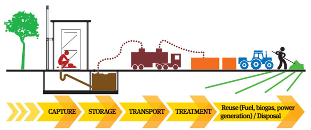
Faecal Sludge and Septage Management (FSSM):
- In 2017, India became one of the first countries to announce a national policy on FSSM, recognising the gaps in sanitation coverage and committing to filling them.
- Human excreta management is a top priority for FSSM, as it is the waste stream with the greatest risk of disease transmission.
- It’s a low-cost, scalable sanitation system that focuses on safe human waste collection, transportation, treatment, and reuse.
- As a result, FSSM promises a time-bound approach to achieving the Sustainable Development Goals (SDG) target 6.2 of providing sufficient and equitable sanitation for all.
Initiatives that are related:
- The launch of the Open Defecation-Free (ODF) + and ODF++ protocols, an emphasis on FSSM in Swachh Survekshan, and financial allocations for FSSM across the Atal Mission for Rejuvenation and Urban Transformation (AMRUT) and National Mission for Clean Ganga (NMCG) missions have all demonstrated India’s commitment to FSSM.
Sewage Treatment Plant Capacity in India:
- Sewage Treatment Plants (STPs) in India can process a little more than a third of the sewage generated every day, according to the latest report from the Central Pollution Control Board (CPCB).
- India produced 72,368 MLD (million litres per day), while STPs had a capacity of 31,841 MLD (43.9 percent ).
- Maharashtra, Gujarat, Uttar Pradesh, Delhi, and Karnataka are the five states and Union Territories (UT) that account for 60% of the country’s total installed treatment capacity.
Solid Waste Management Issues:
- There is no waste separation at the source.
- Urban Local Bodies are short on money for trash management (ULB).
- Inadequate institutional arrangements and a lack of technical skills.
- ULBs’ aversion to implementing suitable collection, segregation, transportation, and treatment/disposal systems.
- Citizens’ apathy toward waste management as a result of a lack of awareness.
- Lack of community involvement in garbage management and sanitary conditions.
Next Steps
- Using the National Faecal Sludge and Septage Management (NFSSM) Alliance: The National Faecal Sludge and Septage Management (NFSSM) Alliance has played a catalytic role in the FSSM sector in India so far, serving as a ready resource and platform for state and city officials.
- States and cities must invest in capacity building, quality assurance and quality control, and monitoring to ensure long-term sustainability and quality implementation. Furthermore, states must take steps to institutionalise the concept.
- States and towns must move fast to adopt new solutions while keeping the most vulnerable and underserved, women and the urban poor, at the core of this effort.
- As a result, India can set an example for the rest of the world in terms of not only abolishing open defecation but also safely managing comprehensive sanitation.
2.China names for 15 places in Arunachal Pradesh
#GS2-International Relations
Context
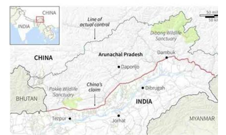
- The Ministry of Civil Affairs of China has established standardised names for 15 locations in the Indian state of Arunachal Pradesh, which will be used on official Chinese maps from now on.
In depth information
Clarification from MEA
- The Chinese “innovation” has been dismissed by the Ministry of External Affairs.
- According to the MEA, Arunachal Pradesh has always been and will always be an integral part of India.
Why is it that places in India are given Chinese names?
- China claims 90,000 square kilometres of Arunachal Pradesh as its own.
- The area is referred to as “Zangnan” in Chinese, and “South Tibet” is mentioned several times.
- Arunachal Pradesh is shown as part of China on Chinese maps, and it is sometimes referred to as “so-called Arunachal Pradesh” in parentheses.
- China takes attempts on a regular basis to emphasise its unilateral claim to Indian land.
- Giving sites in Arunachal Pradesh Chinese names is part of that endeavour.
- Previously, there had been unilateral renamings.
- China has issued the second set of “standardised” names for localities in Arunachal Pradesh.
- It had already provided “official” Chinese names for six locations across Arunachal Pradesh in 2017.
What is China’s justification for claiming these territories?
- The PRC questions the legality of the McMahon Line, the formal border established by the 1914 ‘Convention Between Great Britain, China, and Tibet’ (Simla Convention).
- A plenipotentiary of the Republic of China, which was established in 1912 after the Qing dynasty was deposed, represented China at the Simla Convention.
- When the People’s Republic was declared in 1949, the current communist government came to power.
- The Chinese delegate refused to sign the Simla Convention, claiming that Tibet lacked the capacity to enter into international accords on its own.
What is the McMohan Line, and what does it mean?
- The McMohan Line, named after Henry McMahon, the main British negotiator at Shimla, was formed from Bhutan’s eastern boundary to the China-Myanmar border’s Isu Razi pass.
- China claims land in Arunachal Pradesh to the south of the McMahon Line.
- China also relies on historical relationships between the monasteries of Tawang and Lhasa to support its claims.
The purpose of these renamings
- This renaming is part of China’s plan to demonstrate its sovereignty over Indian land.
- China consistently expresses declarations of anger whenever an Indian dignitary visits Arunachal Pradesh as part of this approach.
- Beijing maintains its “consistent” and “clear” attitude that Arunachal Pradesh is in Indian hands.
- These claims have been declared “illegal” by the international community.
Arunachal not all-alone
- Beijing’s foreign policy playbook includes making aggressive territorial claims based on claimed historical injustices against China.
- One example is the claim on Taiwan, as well as the ongoing efforts to alter “facts on the ground” in several disputed islands in the South China Sea.
- The aggressiveness is always backed up by China’s economic and military might, both overtly and covertly.
3.The Chisum- Demchok Road
#GS3-Infrastructure.
Context
- When it traverses the Umling Pass in Ladakh, the Chisumle-Demchok Road becomes the world’s highest motorable road.
In depth information
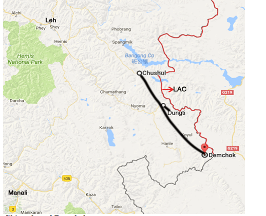
Road between Chisumle and Demchok
- The road through the pass, which was built as part of the Border Roads Organization’s (BRO) Project Himank, was completed in 2017, and cars began to use it in 2018.
- The road is located in the south of Ladakh. It crosses via Umling La Pass, which is over 19,000 feet in elevation.
- The pass’s elevation makes it the world’s highest motorable road, according to Guinness World Records.
- The 52-kilometer tarmac road from Chisumle to Demchok beats the previous record set by a route in Bolivia, which connects the 18,953-foot peak Uturuncu.
- The road was built in extraordinarily difficult conditions, with temperatures in the region dropping to below – 40 degrees Celsius and oxygen levels dropping to half of what they should be.
At the top of the globe
- The road is higher than both base camps for climbing Mount Everest, the world’s highest summit, at the pass.
- The South Base Camp in Nepal is 17,598 feet high, whereas the North Base Camp in Tibet is 16,900 feet high.
- The route between Chisumle and Demchok is also higher than the Siachen Glacier, which stands at 17,700 feet.
- At an elevation of 17,582 feet, the Khardung La in Leh was once one of the world’s highest roadways.
The road’s military significance
- This road connects Chisumle, which is located on the main road connecting Leh, Karu, and Nyoma, with the rest of the world.
- All of these stations are close to the Line of Actual Control and include vital military stations.
- Demchok has already been a hotspot between India and China, having been the site of a stalemate between the two militaries in 2016.
- Demchok has emerged as a source of contention in the present stalemate in eastern Ladakh, which began in May 2020.
The advantages that are available
- The military will benefit from the new axis since it will make it easier to mobilise personnel and supplies, including rations.
- The road would not only allow for faster deployment of armed personnel to the region, but it will also enhance tourism and improve the socioeconomic situation of the region’s residents.
- Certain restrictions apply.
- Route transit will be impossible during the winter, when the armed forces rely on air support, because the road passes via such a high pass.
4.The National Grid:One Nation-One Grid-One Frequency
#GS3- Energy
Context
- The Power Grid Corporation of India Ltd (PGCIL) recently marked the one-year anniversary of the National Grid’s operationalization.
In-depth
National Grid Evolution:
- National grid management on a regional basis began in the 1960s.
- The Indian power system is organised into five regional grids for planning and operational purposes.
- In the early 1990s, the idea of integrating regional networks and establishing a National Grid was conceived.
- State grids were first joined to establish a regional grid, and India was divided into five regions: Northern, Eastern, Western, North Eastern, and Southern.
- The North Eastern and Eastern grids were linked in 1991. It was also connected to the Western area grid in 2003.
- The North and East grids were integrated in August 2006, resulting in four regional grids being simultaneously connected and functioning at the same frequency.
- The Southern Region was connected to the Central Grid on December 31, 2013. As a result, ‘One Nation, One Grid, One Frequency’ will be realised.
- All conceivable precautions are made to keep the grid frequency within the 49.90-50.05 Hz (hertz) range at all times.
One Frequency’s Importance
- Multiple frequencies cannot function alongside each other without destroying equipment, so maintaining a consistent electrical frequency is critical.
- When it comes to providing electricity on a national basis, this has major ramifications.
National Grid Capacity:
- The country’s entire inter-regional transmission capacity is currently around 1,12,250 MW, although this is predicted to increase to almost 1,18,740 MW by 2022.
- The Advantages of a One-Nation-One-Grid-One-Frequency System:
- Demand-Supply Matching: By transferring power from resource-centric regions to load-centric regions, synchronisation of all regional grids will aid in the most efficient use of finite natural resources.
- Electricity Market Development: This would also pave the path for the creation of a thriving electricity market that facilitates power trading between regions.
5.The wheat exports
Tags: GS 3 Agriculture
Context
- In terms of volume, India’s wheat exports increased by more than 527 percent to 3.2 million tonnes (MT) from 0.51 MT in April-October 2020-21.
- Despite worldwide supply disruptions caused by the COVID19 epidemic, India’s cereal exports continue to grow.
In depth information
Why are India’s wheat exports increasing?
- The increase in wheat exports is due to the Agricultural Products Exports Development Authority (APEDA) taking on various initiatives, including organising B2B exhibitions in various countries, exploring new potential markets, and launching marketing campaigns with the active participation of Indian embassies.
- In conjunction with state governments and other stakeholders such as exporters, farmer producer associations, and transporters, it is focusing on creating infrastructure in the value chain to enhance cereal exports.
- It held its first Virtual Trade Fair – India Rice and Agro Commodity Show – in March 2021, with participation from wheat exporters.
- To educate wheat startups with export potential, a sensitization event was developed.
- APEDA has recognised 220 labs across India to provide testing services for a wide range of products and exporters in order to enable smooth quality certification of products to be exported.
India’s wheat exports are now in a state of flux.
- India is the world’s second-largest wheat producer, accounting for roughly 13.53 percent of global production.
- India produces roughly 107.59 MT of wheat per year, with the majority of it consumed domestically.
- Between 2016 and 2020, wheat exports grew at a compound annual growth rate (CAGR) of 48.56 percent.
- In 2020, the country’s wheat exports will reach $ 243 million, up from $ 50 million in 2016.
- In terms of value, India’s wheat exports in the current fiscal year (April – October) increased by 546 percent to $ 872 million, compared to $ 135 million in the previous fiscal year.
- India’s wheat exports are anticipated to reach an all-time high in the current fiscal year (2021-22), having already eclipsed the 2.09 MT shipped in 2020-21.
- India is responsible for less than 1% of global wheat exports.
- Its market share, however, has risen from 0.14 percent in 2016 to 0.54 percent in 2020.
Destinations for export
- In both volume and value terms, Bangladesh has the highest part of India’s wheat exports in 2020-21, accounting for more than 54% in both volume and value terms.
- India will join new wheat markets in 2020-21, including Yemen, Afghanistan, Qatar, and Indonesia.
- Bangladesh, Nepal, the United Arab Emirates, Sri Lanka, Yemen, Afghanistan, Qatar, Indonesia, Oman, and Malaysia are the top 10 importing countries for Indian wheat in 2020-21.
- In both volume and value terms, the top ten nations, which accounted for more than 94 percent of India’s wheat exports in 2016-17, now have a 99 percent share in exports in 2020-21.
Significance
- Higher exports would help India reduce record inventories and give cheaper supplies to Asian clients amid a global price surge due to restricted supplies from big exporters such as Russia and Canada.
Our Courses
Watch Our Videos on YouTube